Monday having been hijacked by Vikings celebrating Lief Ericson's Day, we're holding class Tuesday instead. Columbus day was on Sunday, so if you missed it, and you're Italian, a belated Happy Christopher Columbus Day to you.
Read, in The New England Village,
Chapter 4. Villages in the Federal Period, pp. 88 - 113
Download and Read,
Identification of Historic Landscapes by the National Park Service, which you can find by clicking the button below.
Notes on Readings:
In many ways Chapter 4 is the core of Wood's book. Here we learn that the village forms we traditionally have associated with colonial New England are actually products of the early 19th century. There are some terms you'll need to understand here:
elaboration
Central-Place Theory (note that not all towns or villages are central places)
Town Division as a Process (when and with what results)
Center Villages (and the economic changes which led to their creation)
Turnpikes (and the influence of transportation patterns on town growth or decline)
Give some time to studying the figures showing town development (figures 4.3, 4.4, 4.5, 4.8, 4.10, and 4.11) See if you can form a hypothesis about the different patterns of town development you see in each place.
For Tuesday, October 14
For Wednesday, October 15
Illustrations of these villages played a prominent part in Wood's Chapter 4:
Ware, MA (1637)
Wickford, RI (c. 1780)
Francestown, NH ( 1780, 1800, 1820)
Pittsfield, MA (1780, 1800)
Dedham, MA (1762, 1795, 1817)
Meriden, CT (1780, 1806, and 1835)
Walpole, NH (1780, 1810)
Norwich, VT (1778 , 1820)
Shirley Centre and South Village (1883)
So it is Treasure Hunt Time again. I'd like each of you to fine one or more illustrations, contemporary, or historical, from ONE of the towns listed above and post it with a brief description to your journal. Don't repeat the "finds" of others in the class, which means taking a quick look to see what's been posted before you hunt, yourself. First come, first served, and happy hunting.
For Friday, October 17
Read, in The New England Village,
Chapter 5, "The Village as a Vernacular Form", 114-134
Regarding Chapter 5, it is important to understand the concept "vernacular" To help you with this, I’ve asked you to read the The National Park Service bulletin above.
Spend time looking at the woodcuts and period illustrations in this chapter, not only because they are valuable sources of information, but also because they are quite charming in their own right. The dates of the illustrations are important, as they show the evolution of typical New England townscapes.
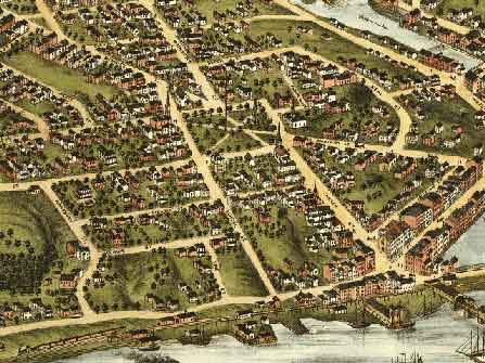
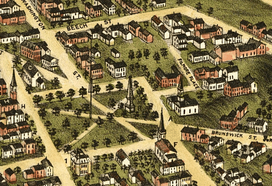
The 19th Century Common at Gardiner, Maine in 1878. Note ways in which this area has been "improved" or "beautified", and compare it with similar areas presented in Wood, Chapters 4 and 5.
Note, too that for all the attempt to beautify this spiritual and culture center of Gardiner, it remains quite irregular. Paths within the common connect important places, and don't complete a symmetrical geometric pattern. Clicking on the image at the right links you to the original image, provided by the Library Of Congress.
Though this is the heart of town, streets like Filmore Place simply peter out. Strangers would have a difficult time knowing where they were or how to get to where they were going. Many irregular green spaces still exist, demonstrating the organic way the town grew. If anything, the outskirts are built more densely than the center is.
You'll find similar situations surrounding the
common here in Bristol, RI
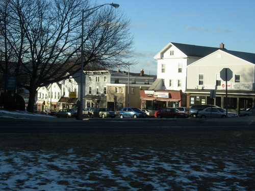
Meriden, Connecticut looks considerably different now, doesn't it? The picture is from Panoramio, a website where thousands of amateur photographers add work of their own...most of the photographs are scenic, and capture impressions which ordinary people find worth recording. Visit it by clicking on the image.